I'm posting backwards it seems; I went to Ottawa a week after we came back from Whitehorse. Just keeping you on your toes over here!
Cam had never been to the Yukon, and hadn't been farther north than Prince George, I think. So it was about time to get this "Cheechako" acquainted with the North.
The Whitehorse kitties were pleased to see us, as was the family of course. (The family is more camera shy than the pets :)

Our first full day in Whitehorse was spent scoping out some sweet downhill trails. Can you guess who lead that pilgrimage?
This is Cam atop Grey Mountain, a prominent peak that overlooks downtown Whitehorse (downtown is just to the left of Cam's head in the valley). The drive to the top of the mountain follows a windy, pot-holed road with a cliff on one side and the mountain on the other. It's a white-knuckler! There's a myriad of trails that crisscross the mountain from top to bottom.

After getting to know Whitehorse for a couple days, we headed off on a road trip to Skagway, Alaska.

Despite what the map below shows, there is a highway between Skagway (marked by "A") and Whitehorse called the Klondike Highway. The highway marked "1" is the famed Alaska Highway.

The Klondike Highway winds through some of the most varied terrain of any road trip. It crosses through the Yukon, BC, and Alaska.
This is Cam in the Carcross Desert, "the smallest desert in the world," near the start of our trip. The desert was formed by deposits from lakes underneath massive glaciers that covered the area thousands of years ago.

We came across our first bear not far down the road!

He attracted quite the paparazzi.

The highway works its way steadily up through the mountains, following long skinny lakes. These lakes were the "water highways" that the gold-seekers used to gain entrance to the Yukon after arriving by boat in Skagway and hiking the Chilkoot trail.
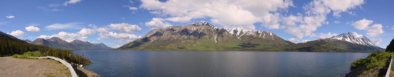


We stopped at the summit to take shots of the snowy peaks and tundra.


Cam explored an icy lake just off the highway. I was hoping he wouldn't fall through.

After the summit, the road starts winding down through a steep valley towards Skagway.

The White Pass train parallels the highway on the opposite side of the valley all the way down into Skagway. At $80 one way, the train isn't exactly affordable!


Skagway is a tiny little town tucked in between towering mountains at the end of an ocean inlet.

It was often the first stop for gold-seekers arriving on ships from the south. From Skagway they trudged up the gruelling Chilkoot trail over the summit.


Now cruise ships are the vessels that mainly dock here in the summer. There were four when we were there! Tourists clogged the main strip of shops, which mostly sell jewellery (from the glaciers of Alaska, ahem, Holland America!).

But we weren't interested in tourist trinkets.


We drove to the Chilkoot trail-head, which is outside of town in another inlet.

It doesn't look that intimidating here, but the trail is a challenging 53 km. Some people can do it in two days, but most take three or four.

After checking out Skagway we decided to head back. The Canadian border guards were suspicious as to why we hadn't bought any souvenirs or booze and only took photos!
On the drive back Cam snapped this great shot of a mother and her cub!


We stopped in the little town of Carcross on the way back. There's a really great ice cream shop here, if you're ever in this neck of the woods, but sadly it was closed :(


Nice scenery. The snow plow engine pic is cool.
ReplyDeleteXO Mom
Absolutely fantastic pictures. I wish there was another page of them to see.
ReplyDelete